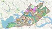
Township Introduces Interactive GIS Map
Clark Township is excited to announce the launch of its new Interactive GIS Map, a powerful resource designed to provide residents, businesses, and developers with easy access to essential information about our community. Developed in partnership with Topology, this GIS-based tool marks the beginning of a robust platform that will continue to evolve.
What Can You Explore?
The map offers a user-friendly experience to help you locate:
- Ward Boundaries: Identify your local representatives.
- Recycling Zones: Stay informed about collection schedules.
- Zoning Information: Understand local land use and development regulations.
- Flood Hazard Areas: Check your property’s flood risk.
- Municipal Boundaries and Open Spaces: Discover the natural and administrative layout of Clark Township.
Important Note:
This map is intended for general reference only. For detailed zoning inquiries, determinations, or additional information, we encourage you to contact the Township directly at 732-428-8401.
We’re also committed to further enhancements of this tool, such as incorporating land use board approvals, engineering permits, and other key datasets, to streamline decision-making and public access.
Explore the map here: Clark Township Interactive Map.
Take a moment to navigate Clark Township’s new GIS system and discover everything our community has to offer!